Font
Color
Images
Font
Sans-serifSerif
Letter spacing
BasicLargeVery large
Font size
SmallMediumLarge
Color schemeа
LightBlackBlue
Reset settingsClose
"ZOV Maps" - Mobile geoinformation complex for tactical use "ZOV Maps" - Mobile geoinformation system for tactical purposes - Dark logo
  • Products
    • ZOV Maps
    • Kvant
  • Download
    • Programmes
      • ZOV Maps
      • Kvant
    • Tile cards
    • Thematic maps
    • Terrain matrices
    • Address databases
  • News
  • Knowledge base
    • Instructions and manuals
    • Examples of use
Customer Support Search
  • RU Русский
  • AR العربية
  • KO 한국어
  • HI हिन्दी
  • EN English (UK)
  • FR Français
  • ES Español

Log in or create an account:

"ZOV Maps" - Mobile geoinformation complex for tactical use "ZOV Maps" - Mobile geoinformation system for tactical purposes - Dark logo
  • Products
    • ZOV Maps
    • Kvant
  • Download
    • Programmes
      • ZOV Maps
      • Kvant
    • Tile cards
    • Thematic maps
    • Terrain matrices
    • Address databases
  • News
  • Knowledge base
    • Instructions and manuals
    • Examples of use
Назад

Language

  • RU Russian
  • AR العربية
  • KO 한국어
  • HI हिन्दी
  • EN English (UK)
  • FR Français
  • ES Español
EN
Select language
Accessibility mode
Customer Support
Telegram канал
  • Main
  • Functionality update

Category: Functionality update

Меню

Categories

  • All 12
  • News 11
  • Functionality update 3

New Articles

  • Версия «ZOV Карты» 14.20.1
  • С Днём Защитника Отечества, Доблестные Русские Воины!
  • Версия «ZOV Карты» 14.20
  • С ДНЁМ ВОЕННОГО ТОПОГРАФА!
  • Mobile software package for geoinformation support "ZOV Maps" (User Manual), version 1.1
Показать категории
Версия «ZOV Карты» 14.20.1

Версия «ZOV Карты» 14.20.1

Основные изменения:1) Исправлена ошибка случайного неотображения / исчезания...

10.03.2026 News
Read more
Версия «ZOV Карты» 14.20

Версия «ZOV Карты» 14.20

Основные изменения:1) Добавлено чтение и отображение формата *.PGD,...

18.02.2026 News
Read more
The first phase of the colour map of elevation cross sections at 5 metres is available

The first phase of the colour map of elevation cross sections at 5 metres is available

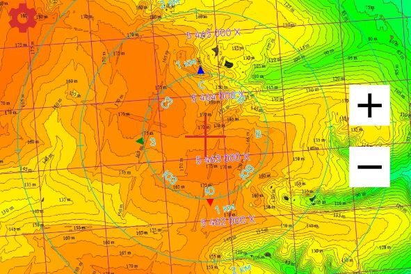
Introducing the first phase of the colour map of elevation cross sections at 5 metres....

02.02.2025 Functionality update
Read more

Categories

  • All 12
  • News 11
  • Functionality update 3

New Articles

  • Версия «ZOV Карты» 14.20.1
  • С Днём Защитника Отечества, Доблестные Русские Воины!
  • Версия «ZOV Карты» 14.20
  • С ДНЁМ ВОЕННОГО ТОПОГРАФА!
  • Mobile software package for geoinformation support "ZOV Maps" (User Manual), version 1.1
ZOV MAPS

Subscribe to our Telegram to stay updated

Subscribe

Products

  • ZOV Maps
  • Kvant

Download

  • Programmes
  • Tile cards
  • Thematic maps
  • Terrain matrices
  • Graphics layers
  • Address databases

Users

  • Support Service

Contacts

  • info@zovmap.com

* The information on this site is sourced from public/open sources

  • Telegram

© 2026 ZOV MAPS. All rights reserved

Privacy Policy Sitemap Made by Infoteq
Quick Links
Programmes Tile cards